
Crater Lake National Park, Oregon
Early the following morning, we made for Crater Lake. We left I5 in Medford, and climbed the 7,000-foot road to Crater Lake.
 Crater Lake from the Rim Village Lodge |
I had been there many years ago, as a kid. But I never realized just how incredibly blue it was! Some 7700 years ago, this mountain (comparable in size to Mt. Shasta, still visible, if only barely, to the south) blew its top in an eruption that geologists say made the Mount St. Helens eruption seem like a hiccup: the top mile of the mountain was blasted into the atmosphere, along with pyroclastic matter from a magma chamber below the mountain. What debris that was left slid back into the resulting hole, forming the steep-sided bowl that is now filled with water. |
| Since the lake's only source of water is the rain and snow that falls within the rim, no rivers carry silt into the lake. And since that water is so cold, very little algae grows in it. It is for these reasons that the lake is so blue: you are seeing the color of 1900+ feet of almost-pure water. |
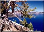
 Pines Grow along the Edge of the Caldera |
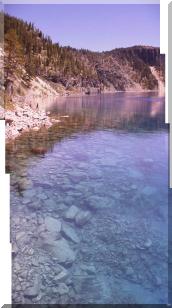
 Cleetwood Trail to the Lake's Edge |
A hike down Cleetwood trail affords a view from lake level. From there, you can look down into the clear blue water, watching the bottom just drop off into sapphire-tinted depths. You can even watch schools of trout swim by.... This image consists of four digicam photos spliced together to get a vertical pan. (Ricoh RDC-300Z) |
| The Trip, in Order: |
| Introduction |
| California I5 |
| Crater Lake, OR |
| Clear Lake, OR |
| Disk Dog Championship |
| Victoria BC |
| Butchart Gardens |
| Olympic National Park, WA |
| Oregon Coast |
| Eureka, CA |
This page is Copyright © MediusRes.Com and
Thomas M. Tuerke 1997-2025
unless otherwise indicated
All Rights Reserved
Reproduction or distribution without prior written permission is strictly prohibited.
Scripting and DHTML by Technomancer Software
technomancer.ws
Privacy Policy
unless otherwise indicated
All Rights Reserved
Reproduction or distribution without prior written permission is strictly prohibited.
Scripting and DHTML by Technomancer Software
technomancer.ws
Privacy Policy